
Lewis and Clark Depart: Mapping the American West
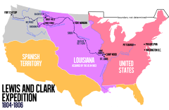
Meriwether Lewis pushed a 55-foot keelboat into the Ohio River at Pittsburgh, Pennsylvania, at 11:00 AM on August 31, 1803, beginning the most important overland expedition in American history. Lewis and his co-commander William Clark would spend the next two years and four months traveling over 8,000 miles to the Pacific Ocean and back, mapping a continent that no American had crossed and returning with knowledge that would shape the nation's westward expansion for a century. President Thomas Jefferson had been planning the expedition before the Louisiana Purchase made it urgent. He wanted a practical route to the Pacific for American trade, scientific documentation of the continent's geography and natural resources, and diplomatic contact with the Native American nations who controlled the interior. Jefferson chose Lewis, his personal secretary and a skilled frontiersman, to lead the mission. Lewis recruited Clark, a former army officer and experienced wilderness navigator, as his co-commander. Together they assembled a company of roughly 45 men, a mix of soldiers, frontiersmen, and specialists including a blacksmith, a carpenter, and an interpreter. The keelboat departure from Pittsburgh was inauspicious. The Ohio River was low, and the boat scraped bottom repeatedly. Lewis spent weeks navigating to the Falls of the Ohio at Louisville, where Clark joined the expedition. They wintered at Camp Dubois near St. Louis before heading up the Missouri River in May 1804 with a fleet of three boats. The journey upstream through the Great Plains brought encounters with the Sioux, Mandan, and other nations. At the Mandan villages in present-day North Dakota, they hired the French-Canadian fur trader Toussaint Charbonneau and his Shoshone wife, Sacagawea, whose knowledge of the mountain passes and ability to communicate with western tribes proved essential. The expedition crossed the Rocky Mountains, nearly starved in the Bitterroot Range, and reached the Pacific coast in November 1805. They returned to St. Louis on September 23, 1806, to a hero's welcome. The journals they kept documented 178 plants and 122 animals unknown to Western science, established relationships with dozens of Native American nations, and provided the maps and intelligence that made American settlement of the West conceivable. The expedition did not find the hoped-for water route to the Pacific, but it established the American claim to the Oregon Country and opened the floodgates of westward migration that would transform the continent within two generations.
August 31, 1803
223 years ago
Key Figures & Places


What Else Happened on August 31
Empress Theodora had ruled the Byzantine Empire since 1042, holding the throne first with her sister Zoe and then alone. She was 76. She'd been pulled from a co…
The Haudenosaunee Confederacy — the Iroquois League — bound five nations together under a constitution called the Great Law of Peace. The exact date is disputed…
Al-Kamil ascended to the Ayyubid sultanate, inheriting a realm under siege by the Fifth Crusade. By prioritizing diplomacy over total war, he successfully negot…
Al-Kamil became Sultan of the Ayyubid Empire upon his father Al-Adil's death in 1218, inheriting control of Egypt, Syria, and northern Mesopotamia at a moment w…
King Håkon V Magnusson shifted the Norwegian capital from Bergen to Oslo, consolidating his power in the eastern territories. This move permanently altered the …
A massive earthquake estimated between 8.8 and 9.4 magnitude struck Chile's Atacama Region around 1420, generating a trans-Pacific tsunami that reached the coas…
Talk to History
Have a conversation with historical figures who witnessed this era. Ask questions, explore perspectives, and bring history to life.