
GPS Treasure Hunt: Geocaching Begins Global Adventure
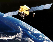
Dave Ulmer wanted to test whether the newly unscrambled GPS signal was accurate enough to find a hidden container in the woods. On May 3, 2000, just two days after President Clinton removed the military's deliberate degradation of civilian GPS signals, the Oregon computer consultant buried a black bucket near Beavercreek, Oregon, filled it with a logbook, a pencil, videos, books, software, and a slingshot, and posted the coordinates to a Usenet GPS enthusiast group with a simple challenge: find it. Within three days, two people had located the bucket using handheld GPS receivers. Mike Teague, one of the early finders, began cataloging similar hides on his personal website, creating the first online database of what participants initially called "GPS stash hunting." The name "geocaching" emerged within weeks, combining "geo" for earth and "cache" for a hidden store, and the community adopted it. The activity spread with remarkable speed through early internet forums and mailing lists. By September 2000, Jeremy Irish launched geocaching.com, which became the central platform for listing and logging caches worldwide. The rules were simple: hide a waterproof container at a specific coordinate, register it online, and let other players find it using GPS. Finders signed the physical logbook and logged their visit online. Many caches contained small trinkets for trading. The timing was perfect. Consumer GPS receivers were becoming affordable, accuracy had just improved tenfold, and the internet provided the communication infrastructure to organize a global game with no central authority. Geocaching attracted hikers, puzzle enthusiasts, and families looking for outdoor activities with a technological twist. The hobby grew into a worldwide community with over three million active caches hidden across every continent, including Antarctica. Geocaching.com reports that players have logged more than two billion finds. What began as one man's curiosity about satellite accuracy became an enduring fusion of technology and outdoor exploration.
May 3, 2000
26 years ago
Key Figures & Places


What Else Happened on May 3
Ethnic violence erupted between the Meitei and Kuki Zo communities in Manipur, triggered by disputes over land rights and affirmative action status. This confli…
Bird Jaguar IV ascended the throne of Yaxchilan, ending a ten-year interregnum that had paralyzed the city-state’s leadership. By aggressively commissioning mon…
The ground shook three times in 24 hours, but it was the third quake that dropped Rhodes into the sea. Thirty thousand people died when the city's limestone bui…
The monarch took a new name, João, and ordered his entire court to follow him into baptism. Nkuwu Nzinga of Kongo wasn't conquered—he invited the Portuguese pri…
Columbus had already mapped 700 miles of Cuban coastline when his crew spotted mountains rising from turquoise water. May 5, 1494. He named it Santiago, convinc…
The French called it "Matanzas" too—the same name the Spanish had used for their massacre site, which meant "slaughters." Dominique de Gourgues led 150 Frenchme…
Talk to History
Have a conversation with historical figures who witnessed this era. Ask questions, explore perspectives, and bring history to life.